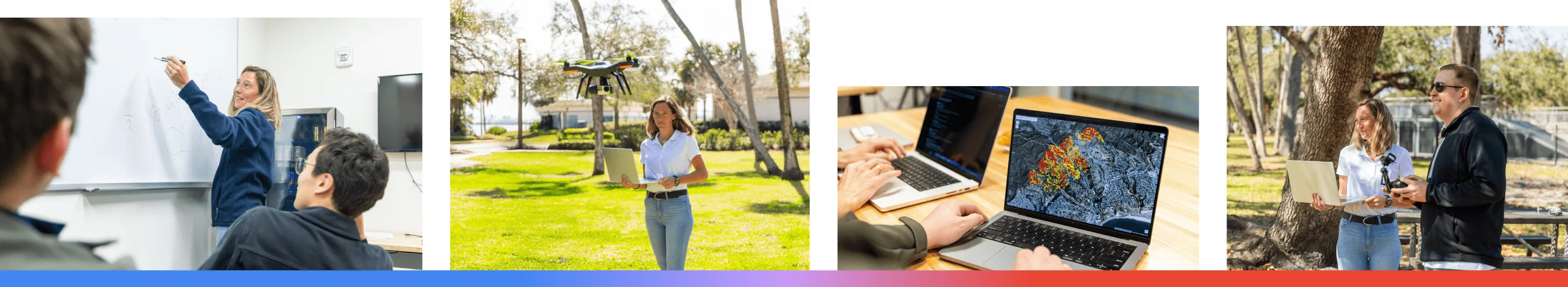
My background is in aerospace engineering. I was working on the integration of drones and air traffic management when I met a wildfire scientist who recognized the incredible potential of translating what I was doing with real-time data simulation to wildfire management. She explained how unpredictable wildfires are, the challenges of modeling them, and the critical need for real-time data. We started working together, and with supportive funding, started SkyTL (formerly Improving Aviation). About four years later, we just rolled out our product.
Our goal was to give firefighters, communities, and insurance companies really good data about where a fire might go, especially the embers. There's a decent understanding of how fires propagate through the ground fire but not how those ashes are transported ahead of the fire.
If we want to keep firefighters safe, we need to be able to model how those ashes move and ignite. When we started dissecting why they weren’t using any technology in the field, we found out there were a few key reasons: There isn’t good, real-time input data, like wind imagery; the models and algorithms implemented in university labs took so long to run they were only being used after fires took place; and they were way too complicated for firefighters to use in real time.
We had to convert the models into a package that’s super fast and super easy. That's where Google Cloud and AI came in, speeding up the process so you get answers in real-time to make an informed decision.
AI helps in two main ways. It learns from these complex physics equations and then quickly approximates the result. And it helps us understand the landscape. We use computer vision and AI to identify vegetation in real time, down to individual trees. This lets us know exactly what's there and how it might burn.
Google Cloud was crucial because it gave us the scale to run multiple deployments in multiple places for different customers, and it gave us a great data simulation process. Dataflow allows us to bring in and process real-time data, and then we deploy our models in Vertex AI, which is super flexible, letting us use existing models as well as our own.
We also built a huge library of past fires, so we trained the Gemini model with that data set, teaching the AI the conditions that caused those fires and ultimately enabling it to predict—and hopefully mitigate—future fires.
For example, we did a pilot program with a firefighting agency for a few years, and when a fire broke out last summer, the models they previously used indicated that fire would move north. But our AI saw the embers jumping the river, heading south, and threatening a nearby community. We ran our model, warned them, and they were able to set up defenses, so when the fire jumped, the community was safe.
Beyond the private sector wildfire efforts, we're also working with the government to manage firefighting aircraft – drones, helicopters, and planes – making sure they can coordinate safely and effectively. Looking ahead, we want to expand to floods and hurricanes—a particularly relevant one for me in Florida. We’re also interested in smart cities, using sensors to optimize everything from power grids to traffic. Our focus is always on taking real-time data from the field and using advanced prediction models to solve real-world problems.
Honestly, I don't think any of this would have been possible ten years ago. The cloud tech, the AI advancements – it's given small companies like ours the chance to take scientific knowledge and actually build something impactful. It's opened the door for breakthroughs and getting those ideas out into the real world.